Three hours from Seattle sits a park with more than 300 glaciers, the most of any American park outside Alaska, that logs fewer visitors than almost any of the 63. The trick is in the map: the highway everyone drives runs between the park's two halves without ever entering either one.
North Cascades is one of 63 national parks in ParkStamp, and like all of them it gets original stamp designs in the WPA poster tradition: each one an illustration of an actual named place, not a generic mountain.
The visit itself is free to record. Check in from the trailhead, backfill a climb from years back, or let the app read dates and locations from the photos your phone already holds.
The real NPS boundary, with the roads and towns you would actually use to get there.
North Cascades, for people who count parks
A park with almost no roads, a lake the color of antifreeze, and Kerouac on fire watch.
The visitation numbers are an accounting artifact. Congress drew this park in 1968 as a complex: two blocks of park, north and south, with Ross Lake National Recreation Area threaded between them along the Skagit River, and Lake Chelan National Recreation Area hanging off the southern tip. Highway 20, the North Cascades Highway, runs entirely through the recreation area, so the hundreds of thousands of people who drive it each year mostly never count as park visitors. The park proper is nearly roadless; the unpaved Cascade River Road is the main way to actually drive into it. That is how a park within a morning's drive of Seattle records some of the lowest visitation in the system.
October 2, 1968 was a two-park day. Lyndon Johnson signed North Cascades and Redwood into existence the same day, along with the Wild and Scenic Rivers Act. It was probably the single best signing day in conservation history. The push here came from a decade-long fight over whether these valleys would be logged; the Sierra Club's 1957 film about the "wilderness alps" of Stehekin helped swing it. The dams came first, though: Seattle City Light built Gorge, Diablo and Ross dams on the Skagit starting in the 1920s to power the city, and Diablo Dam was briefly the tallest dam in the world when it was finished in 1930. The park was drawn around the powerhouses, which is why they sit in a recreation area instead.
Jack Kerouac spent the summer of 1956 alone on Desolation Peak above Ross Lake, working as a fire lookout, facing Hozomeen Peak for 63 days. The experience produced chunks of The Dharma Bums and Desolation Angels, and the lookout still stands. A trail goes up; it is a serious day.
Stehekin still has no road to anywhere. The community at the head of Lake Chelan is reached by boat, floatplane, or on foot over the passes; mail and groceries come up the lake. And people have crossed this range far longer than that: at Cascade Pass, archaeologists have traced human use back thousands of years, hearths under what is now a day-hiker's lunch spot.
Glaciers by the hundred, and a grizzly bear-shaped vacancy.
More than 300 glaciers, roughly a third of all the glaciers in the lower 48. Nowhere else in the contiguous United States concentrates ice like this, because nowhere else stacks 9,000-foot relief directly in the path of Pacific storms. The glaciers feed the Skagit, which still carries all five species of Pacific salmon, which in turn feed one of the largest winter gatherings of bald eagles in the lower 48 downstream of the park. The ice is shrinking, and the park has measured it shrinking for decades.
The last confirmed grizzly on the American side was seen in 1996. The North Cascades were grizzly country for thousands of years until hide hunters and then habitat loss emptied them. In 2024, after decades of studies and reversals, the federal government decided to bring them back by moving bears in from healthy populations, making this one of the few places in America where the plan is more grizzlies. Wolverines never left entirely: they den in the deep spring snowpack, and researchers keep finding them on camera traps.
The park runs from rainforest to near-desert in about fifty miles. The west side soaks under Pacific storms and grows western red cedar and hemlock; the east side sits in the rain shadow and grows ponderosa pine. Stack that gradient on top of 9,000 feet of vertical and you get a plant list that runs past 1,600 species, one of the richest in any American park, plus mountain goats, pikas, black bears, and marmots whistling from the talus.
The North Cascades designs
Pick the one that matches the park you actually saw.
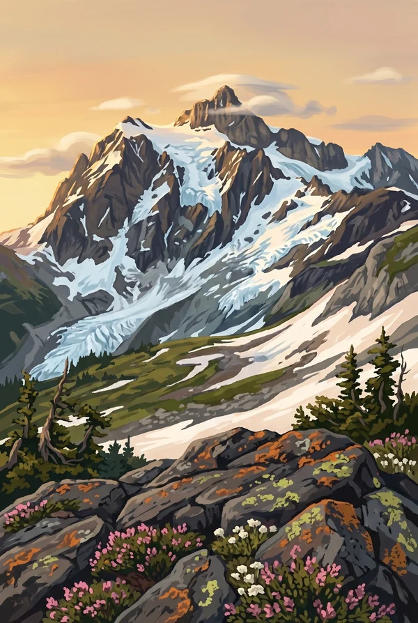
Mt Shuksan
A 9,131-foot non-volcanic peak of ancient seafloor rock standing next door to the volcano Mount Baker, and a strong candidate for the most photographed mountain in America. The famous shot, Shuksan doubled in the still water of Picture Lake, is actually taken from just outside the park boundary, which feels appropriate for this park.
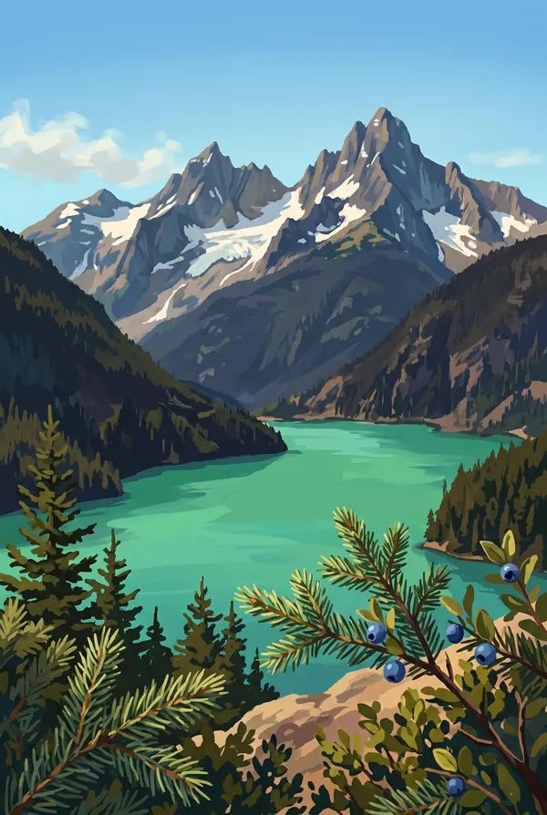
Diablo Lake Overlook
The pullout on Highway 20 above a reservoir that looks dyed. Glaciers upstream grind rock into flour so fine it hangs suspended in the water and scatters sunlight blue-green; the color is strongest in late summer when melt peaks. The dam that made the lake was briefly the tallest in the world in 1930. Easiest classic view in the park.
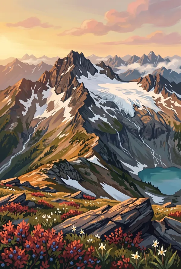
Sahale Arm
The ridge walked up from Cascade Pass, a trade route humans have crossed for thousands of years, ending at tent sites perched on the moraine below Sahale Glacier at around 7,600 feet. On a clear day the view is an unbroken sea of ice and rock in every direction. Many people who have hiked everywhere call this the best walk in Washington.
How to record your North Cascades visit
Free, and it works whether you are standing there now or remembering a trip from years ago.
1
Check In at the park
Open ParkStamp inside the park boundary and check in. The app confirms you are actually there and logs the date.
2
Or Stamp It later
Already been? Pick the date yourself. Trips from decades ago count the same as last weekend.
3
Or scan your photos
Let ParkStamp read the dates and locations off photos already on your phone. Most people find parks they had forgotten.
North Cascades, asked and answered
Quick answers, for people planning a trip and people remembering one.
When is the best time to visit North Cascades?
Mid-July through September, and the window is real: the high country holds snow into summer, and Highway 20 is typically snowed shut from late fall well into spring. August brings the best odds of clear peaks and the strongest turquoise in Diablo Lake, when glacial melt peaks. Early October adds gold larches near the high passes for those willing to gamble on weather.
How many days do you need at North Cascades?
One day driving Highway 20 collects the overlooks (Diablo Lake, Washington Pass) but barely enters the park proper. Give a second, long day to Cascade Pass and Sahale Arm, the best walk in the park. Stehekin is its own trip: the boat up Lake Chelan makes it a two-day commitment minimum, which is exactly why it stays quiet.
How busy is North Cascades?
North Cascades National Park logged 46,925 visits in 2025, the 57th busiest of the 63 national parks. That makes it one of the quieter national parks, and crowds are rarely the problem.
What does the North Cascades stamp show?
The lead North Cascades design is Mt Shuksan. A 9,131-foot non-volcanic peak of ancient seafloor rock standing next door to the volcano Mount Baker, and a strong candidate for the most photographed mountain in America. The famous shot, Shuksan doubled in the still water of Picture Lake, is actually taken from just outside the park boundary, which feels appropriate for this park. The other two designs are Diablo Lake Overlook and Sahale Arm.
Is the North Cascades stamp free?
Recording your North Cascades visit is always free: check in at the park, add an old trip, or let the photo scan find it. The full-color art is the paid part, $3.99 one-time with three North Cascades designs to choose from, and the first stamp you collect in ParkStamp is free.
Can I add a North Cascades trip from years ago?
Yes. Open North Cascades in ParkStamp, tap Stamp It, and set the date yourself; a visit from decades ago counts the same as last weekend. If you still have photos from the trip, the photo scan can find and date it from their location tags, without your photos ever leaving your phone.
Do I have to be at North Cascades to get the stamp?
No. Check In is for when you are standing inside North Cascades, and it confirms you are actually there. Stamp It records any past visit on your honor, with your dates. Both are free and put the same stamp in your StampBook.
Start your StampBook with North Cascades
Free on iOS and Android. Your first stamp is on us.