Haleakalā means House of the Sun: this is the summit where, in the Hawaiian tradition, the demigod Māui snared the sun to slow its crossing. The road to the top climbs from the sea to 10,023 feet in about 37 miles, one of the steepest such ascents anywhere, and ends at the rim of a valley so large and so strange that everyone calls it a crater, even though it is not one.
Haleakalā is one of the 63 national parks in ParkStamp, and every park in the app has original stamp designs made in the WPA poster tradition. Each design is an illustration of a specific real place in the park.
Logging your visit is free. Check in at the park, enter a trip from years back, or let the app lift the dates and locations from photos that are already on your phone.
The real NPS boundary, with the roads and towns you would actually use to get there.
Haleakalā, for people who count parks
A crater that is really a canyon, and a volcano that is only resting.
The park predates statehood by four decades. Congress created Hawaii National Park on August 1, 1916, the same month the Park Service itself was born, combining Haleakalā on Maui with the volcanoes of the Big Island in a single park spread across two islands. The arrangement lasted until 1961, when Haleakalā was split off as a national park in its own right.
The crater is an impostor. The summit depression, about seven miles long, two miles wide, and roughly 2,500 feet deep, was not blasted out by an eruption. Water did it: two great stream valleys ate into opposite sides of the mountain until their heads met near the top. Later eruptions then paved the floor and studded it with cinder cones in rust, ash-gray, and near-black, which is why the interior looks so convincingly volcanic. It is a canyon wearing a crater costume.
The volcano is dormant, not done. For years the last eruption was dated to about 1790; radiocarbon work has since pushed it back centuries, to somewhere roughly between 1480 and 1600. On a volcano's calendar that is recent, and geologists expect Haleakalā to erupt again someday, just not on any schedule worth planning around.
The park runs to the sea, which surprises people. The Kīpahulu District, on Maui's wet windward side past Hāna, protects a separate world: rainforest, waterfalls, and the stream of ʻOheʻo stepping down through pools to the ocean. There is no road between it and the summit district through the park; the mountain in between is the point.
A silver plant that blooms once and dies, and seabirds nesting at 10,000 feet.
The silversword is the park's emblem for a reason. ʻĀhinahina grows on the volcano's high cinder slopes and nowhere else on Earth: a sphere of sword-shaped leaves covered in silver hairs that reflect the fierce summit light. It can live for decades, blooms exactly once, sending up a flower stalk taller than a person, and then dies. A century ago souvenir collectors and feral goats had nearly finished it off; protection and fencing brought it back from the edge.
Seabirds nest near the summit. The ʻuaʻu, the endangered Hawaiian petrel, digs nesting burrows into the high slopes and crater rim, then commutes to the open ocean to feed, returning after dark. Haleakalā shelters one of the most important colonies left anywhere, and on summer nights the birds' calls carry over the cinder fields.
The nēnē was nearly gone. Hawaii's native goose, a Canada goose lineage remodeled by the islands with reduced webbing for walking on lava, was down to a few dozen birds in the mid-twentieth century. Captive-bred nēnē were released in the park beginning in the early 1960s, some famously packed into the crater on foot, and a wild population lives here again.
The stakes are high on this mountain generally: isolated for millions of years, Hawaiian ecosystems evolved with no defenses against introduced predators and grazers, and the park has spent decades fencing boundaries and removing invaders. The Park Service has noted that this small park is home to more endangered species than almost any other in the system.
The Haleakalā designs
Pick the one that matches the park you actually saw.
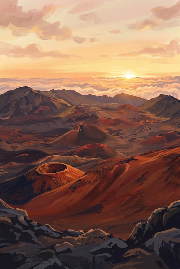
Haleakala Crater
The summit valley itself: seven miles of cinder cones, lava flows, and shifting color, 2,500 feet below the rim, with the Keoneheʻeheʻe trail switchbacking down into it through sand that squeaks underfoot. Clouds pour through the gaps in the walls where the old stream valleys broke in. Sunrise from the rim above it is the classic Maui pilgrimage.
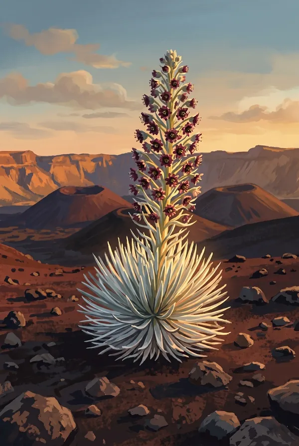
Silversword
The plant found only on this mountain: a globe of silver blades built to survive at 10,000 feet, sometimes decades old, that flowers once in its life, sending up a stalk of hundreds of blooms, and then dies. Nearly wiped out a century ago, rescued by protection. The natural pick for anyone who crouched beside one on the cinder and took the photo.
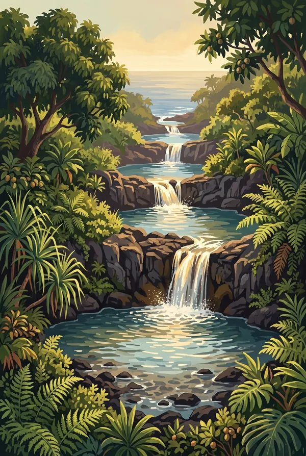
Pools of 'Ohe'o
The stair-step pools of ʻOheʻo Gulch in the Kīpahulu District, where the stream drops through terraced basins to the sea. Mid-century promoters renamed them the Seven Sacred Pools; there are more than seven and they were never sacred, and the Park Service has spent decades saying so. Above them, the Pīpīwai Trail climbs through bamboo to the 400-foot Waimoku Falls.
How to record your Haleakalā visit
Free, and it works whether you are standing there now or remembering a trip from years ago.
1
Check In at the park
Open ParkStamp inside the park boundary and check in. The app confirms you are actually there and logs the date.
2
Or Stamp It later
Already been? Pick the date yourself. Trips from decades ago count the same as last weekend.
3
Or scan your photos
Let ParkStamp read the dates and locations off photos already on your phone. Most people find parks they had forgotten.
Haleakalā, asked and answered
Quick answers, for people planning a trip and people remembering one.
When is the best time to visit Haleakalā?
Any month (Maui's seasons are subtle), but the mountain makes its own weather. The summit can sit below freezing before dawn in any season, then burn clear by mid-morning, and clouds often flood the crater by afternoon, so go early for the views. Summer is when silverswords tend to send up their once-in-a-lifetime blooms. Kīpahulu is rainforest: expect showers year-round, heaviest in winter.
How many days do you need at Haleakalā?
Two days, because this is really two parks. Give the summit one day (sunrise or sunset from the rim, then a walk down Keoneheʻeheʻe into the crater as far as your legs allow) and give Kīpahulu another, since it sits at the far end of the Hāna road, with the ʻOheʻo pools and the bamboo climb to Waimoku Falls. A third day lets you cross the crater floor properly.
How busy is Haleakalā?
Haleakalā National Park logged 853,711 visits in 2025, the 27th busiest of the 63 national parks. That puts it in the middle of the pack: busy at the famous spots, quiet a mile past them.
What does the Haleakalā stamp show?
The lead Haleakalā design is Haleakala Crater. The summit valley itself: seven miles of cinder cones, lava flows, and shifting color, 2,500 feet below the rim, with the Keoneheʻeheʻe trail switchbacking down into it through sand that squeaks underfoot. Clouds pour through the gaps in the walls where the old stream valleys broke in. Sunrise from the rim above it is the classic Maui pilgrimage. The other two designs are Silversword and Pools of 'Ohe'o.
Is the Haleakalā stamp free?
Recording your Haleakalā visit is always free: check in at the park, add an old trip, or let the photo scan find it. The full-color art is the paid part, $3.99 one-time with three Haleakalā designs to choose from, and the first stamp you collect in ParkStamp is free.
Can I add a Haleakalā trip from years ago?
Yes. Open Haleakalā in ParkStamp, tap Stamp It, and set the date yourself; a visit from decades ago counts the same as last weekend. If you still have photos from the trip, the photo scan can find and date it from their location tags, without your photos ever leaving your phone.
Do I have to be at Haleakalā to get the stamp?
No. Check In is for when you are standing inside Haleakalā, and it confirms you are actually there. Stamp It records any past visit on your honor, with your dates. Both are free and put the same stamp in your StampBook.
Start your StampBook with Haleakalā
Free on iOS and Android. Your first stamp is on us.