The Wrangell-St. Elias National Park & Preserve Stamp
This is the largest national park in the United States, and it is not close: 13.2 million acres, about six Yellowstones, holding nine of the sixteen highest peaks in the country. Its most visited destination is a copper mill town abandoned in 1938, at the end of a long gravel road, beside a glacier most people mistake for a gravel pit.
Wrangell-St. Elias is one of the 63 national parks in ParkStamp, each of which gets original stamp designs drawn in the WPA poster tradition: illustrations of specific real places, not interchangeable mountain scenery.
Recording that you were here is free. Check in on the spot, add the trip you took years back, or let the app work out dates and places from photos already on your phone.
The real NPS boundary, with the roads and towns you would actually use to get there.
Wrangell-St. Elias, for people who count parks
Six Yellowstones, one misspelled copper empire, and two gravel roads in.
Four mountain ranges collide here. The Wrangells, the St. Elias, the Chugach and the eastern tail of the Alaska Range all converge inside the park, which is how one park ends up with nine of the sixteen highest peaks in the United States. Mount St. Elias reaches 18,008 feet, second-highest in both the United States and Canada, and Mount Wrangell, over 14,000 feet, is an active volcano that still vents steam. Together with the adjoining Canadian parks and Glacier Bay, this is a UNESCO World Heritage Site and the largest internationally protected wilderness on Earth.
The copper was almost unbelievable. In 1900 two prospectors spotted a green hillside above the Kennicott Glacier and reportedly took it for grass; it was malachite, the surface stain of one of the richest copper deposits ever found, with ore from the Bonanza outcrop assaying around seventy percent copper. Getting it out required building the Copper River & Northwestern Railway, 196 miles across canyons and glacial rivers that critics said could not be crossed. The company misspelled the glacier's name on its incorporation papers, which is why the town is Kennecott and the ice is Kennicott.
In 1938 the last train left, and the town just stopped. The high-grade ore was gone, the mill shut down, and Kennecott was abandoned so quickly that much of the machinery, the shops and the fourteen-story mill were simply left in place. What remained became one of the best-preserved pieces of industrial history in the country, red buildings against white ice, now maintained as a National Historic Landmark inside the park.
The park itself arrived in a political storm. President Carter protected the area under the Antiquities Act in 1978, to loud local protest, and the compromise came on December 2, 1980, when the Alaska lands act created the park and preserve. Alaska's deal is visible on the ground: hunting continues in the preserve, subsistence use continues throughout, and people still live at McCarthy, deep inside the boundary. Only two gravel roads enter the park at all: the McCarthy Road, laid on the old railbed, and the Nabesna Road. Until the late 1990s the final river crossing at McCarthy was made by hand-pulled cable tram. It is a footbridge now. Everything beyond the roads belongs to bush planes and boots.
The continent's biggest glacier collection, with Dall sheep on the walls above it.
This is North America's great ice locker. The park holds the continent's largest collection of glaciers, fed by the Bagley Icefield, the largest subpolar icefield in North America. The Malaspina, a piedmont lobe spreading out where the mountains meet the coastal plain, is bigger than Rhode Island; the Hubbard is the longest tidewater glacier on the continent and, unusually, has been advancing for as long as records exist.
Dall sheep own the high country. The park supports one of the largest concentrations of these white sheep anywhere, picking their way across crags where nothing follows them, with mountain goats holding the steeper coastal ranges. Spotting white animals on grey rock from the Nabesna Road is the park's quietest sport.
The Copper River is the artery. Its salmon runs are famous enough that the river's name sells fish in grocery stores thousands of miles away, and the runs feed everything here: brown and black bears on the tributaries, eagles in the cottonwoods, and people, who still take salmon from the silty current with fish wheels and dipnets near Chitina as they have for generations.
The land animals are spread thin but all present. Moose stand in the kettle ponds along both roads, caribou herds cross the northern flats below the volcanoes, and trumpeter swans, once nearly extinct, nest on the lowland lakes. The park is so large that seeing any of them is a matter of patience, not fences.
The Wrangell-St. Elias designs
Pick the one that matches the park you actually saw.
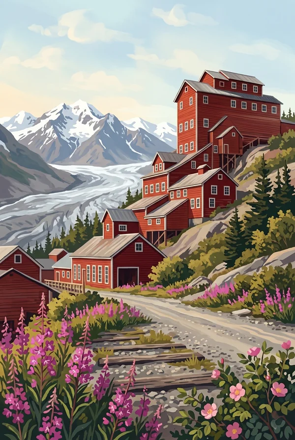
Kennecott Mill and Glacier
The fourteen-story red mill building steps down its hillside exactly as it did when the last train left in 1938. Below it stretches what looks like a valley of gravel and is actually the Kennicott Glacier under a skin of rock debris. Company and glacier spell the name differently thanks to a clerical error. Pick it if ruins move you more than summits.
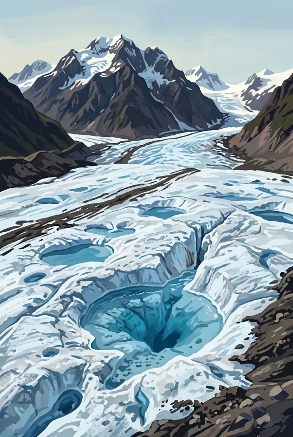
Root Glacier Ice
A live glacier you can walk on: a trail from Kennecott leads onto white ice threaded with meltwater channels and blue pools, with the Stairway Icefall hanging thousands of feet of fractured ice above the valley head. Strap-on crampons and an hour's walk put you on it, which makes this one of the most accessible glacier surfaces in Alaska.
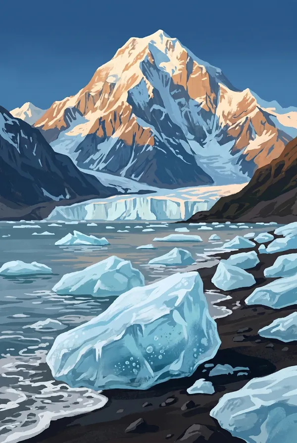
Mount St. Elias from the Coast
At 18,008 feet, the second-highest peak in both the United States and Canada, rising from tidewater at Icy Bay to its summit in roughly ten horizontal miles, one of the steepest rises on the planet. Vitus Bering's 1741 expedition raised it from the sea, at the moment Europe first sighted Alaska. The mountaineer's choice of the three.
How to record your Wrangell-St. Elias visit
Free, and it works whether you are standing there now or remembering a trip from years ago.
1
Check In at the park
Open ParkStamp inside the park boundary and check in. The app confirms you are actually there and logs the date.
2
Or Stamp It later
Already been? Pick the date yourself. Trips from decades ago count the same as last weekend.
3
Or scan your photos
Let ParkStamp read the dates and locations off photos already on your phone. Most people find parks they had forgotten.
Wrangell-St. Elias, asked and answered
Quick answers, for people planning a trip and people remembering one.
When is the best time to visit Wrangell-St. Elias?
Mid-June through August, when the long subarctic days are warmest and the high country is open; this is a park with a short summer and a serious winter. Late August into early September is the connoisseur's window: the tundra turns red and gold, the bugs die off, and fresh snow reappears on the peaks. The gravel roads are at their best in high summer, and by October the park has largely returned to the locals and the cold.
How many days do you need at Wrangell-St. Elias?
Three days is the honest minimum: the McCarthy Road is a slow 60 miles of gravel, and Kennecott and the Root Glacier each deserve a day once you are there. A fourth day for a flightseeing trip past the big peaks and icefields is how you actually see the park, since the roads touch only its edges. The Nabesna Road, on the quieter north side, is a separate trip in itself.
How busy is Wrangell-St. Elias?
Wrangell-St. Elias National Park & Preserve logged 108,840 visits in 2025, the 55th busiest of the 63 national parks. That makes it one of the quieter national parks, and crowds are rarely the problem.
What does the Wrangell-St. Elias stamp show?
The lead Wrangell-St. Elias design is Kennecott Mill and Glacier. The fourteen-story red mill building steps down its hillside exactly as it did when the last train left in 1938. Below it stretches what looks like a valley of gravel and is actually the Kennicott Glacier under a skin of rock debris. Company and glacier spell the name differently thanks to a clerical error. Pick it if ruins move you more than summits. The other two designs are Root Glacier Ice and Mount St. Elias from the Coast.
Is the Wrangell-St. Elias stamp free?
Recording your Wrangell-St. Elias visit is always free: check in at the park, add an old trip, or let the photo scan find it. The full-color art is the paid part, $3.99 one-time with three Wrangell-St. Elias designs to choose from, and the first stamp you collect in ParkStamp is free.
Can I add a Wrangell-St. Elias trip from years ago?
Yes. Open Wrangell-St. Elias in ParkStamp, tap Stamp It, and set the date yourself; a visit from decades ago counts the same as last weekend. If you still have photos from the trip, the photo scan can find and date it from their location tags, without your photos ever leaving your phone.
Do I have to be at Wrangell-St. Elias to get the stamp?
No. Check In is for when you are standing inside Wrangell-St. Elias, and it confirms you are actually there. Stamp It records any past visit on your honor, with your dates. Both are free and put the same stamp in your StampBook.
Start your StampBook with Wrangell-St. Elias
Free on iOS and Android. Your first stamp is on us.