When George Vancouver's crews charted this coast in 1794, Glacier Bay was not a bay. It was a dent a few miles deep in a wall of ice. Today it is a fjord system 65 miles long, which makes this the fastest documented glacial retreat on Earth. The land, freed of all that weight, is rising about an inch a year.
Glacier Bay is one of the 63 national parks in ParkStamp, and like all of them it gets original stamp designs drawn in the WPA poster tradition. Each design is an illustration of a specific real place in the park, not a generic scene.
Recording a visit costs nothing. Check in from the park, log a trip you took years ago, or let the app read the dates and locations off photos already sitting on your phone.
The real NPS boundary, with the roads and towns you would actually use to get there.
Glacier Bay, for people who count parks
A landscape younger than the United States, and a homeland older than the ice.
The bay un-froze within recorded history. Vancouver found the ice front near the mouth in 1794. When John Muir came by canoe in 1879, it had fallen back roughly 48 miles; by the early twentieth century the Grand Pacific Glacier sat about 65 miles up-bay, near where it is now. Geologists get excited about retreats measured in millennia. This one happened in about a century, and it is the standard textbook case.
The Huna Tlingit watched the ice come, not just go. This was their homeland first. During the Little Ice Age the advancing glacier overran their villages in the bay. The oral histories describe an ice front that moved faster than people could believe, and the clans resettled across Icy Strait at Hoonah. In 2016 the tribe and the Park Service dedicated Xunaa Shuká Hít, a carved cedar tribal house at Bartlett Cove, the first permanent clan house in the bay since the glacier pushed the people out.
The scientific case was made by an ecologist counting plants. William S. Cooper, a student of the same Henry Chandler Cowles who invented succession ecology on the Indiana dunes, realized that a retreating glacier leaves a perfect natural experiment: bare rock near the ice, older and older plant communities the farther down-bay you go. He set out permanent study plots in 1916 (still monitored today) and then led the Ecological Society of America's campaign that persuaded Calvin Coolidge to proclaim a national monument in 1925.
Park and preserve status came on December 2, 1980, under the Alaska National Interest Lands Conservation Act, the single biggest land-protection law in American history. Glacier Bay got 3.3 million acres of it, and with its Canadian and Alaskan neighbors it now forms one of the largest internationally protected wilderness areas on the planet, a UNESCO World Heritage site spanning the St. Elias ranges.
No road reaches it. You come by boat or small plane, or you see it from a ship's rail, which is how most visitors experience the park. There is one small dock, one lodge, and a few miles of trail at Bartlett Cove. Everything else is water, ice, and country that has been out from under the glacier for less time than the United States has existed.
Whales that commute from Hawaii, and a forest assembling itself in real time.
Humpback whales, the same individuals every summer. They winter in Hawaiian waters and swim thousands of miles back to feed here, and researchers know many of them personally: the park has run one of the longest continuous whale monitoring programs anywhere, going back to 1985, identifying whales by the unique patterns on their flukes. At Bartlett Cove stands the articulated skeleton of Snow, a humpback killed by a ship strike in 2001, displayed as a plain statement of what the monitoring is for.
Sea otters came back on their own. The maritime fur trade had emptied this coast of them by the early 1800s. Descendants of translocated otters reached the mouth of the bay in the late 1980s, and within a few decades there were thousands inside it: one of the fastest marine mammal recoveries ever documented, reshaping the sea floor as they eat their way through urchins and clams.
The land itself is a time series. Near the glaciers: bare rock and silt. A few miles back: mats of dryas and fireweed, then alder thickets fixing nitrogen into brand-new soil, then cottonwood, then young spruce, and at Bartlett Cove, ice-free the longest, a closed spruce-hemlock rainforest with moss a foot deep. A boat ride up-bay runs the film backward, 250 years of forest assembly in an afternoon.
Both bears, including a blue one. Brown bears work the up-bay shorelines and black bears the forested lower bay, and this corner of Alaska is one of the few places with the glacier bear, a smoky blue-gray color phase of black bear rare enough that most rangers have never seen one.
The Glacier Bay designs
Pick the one that matches the park you actually saw.
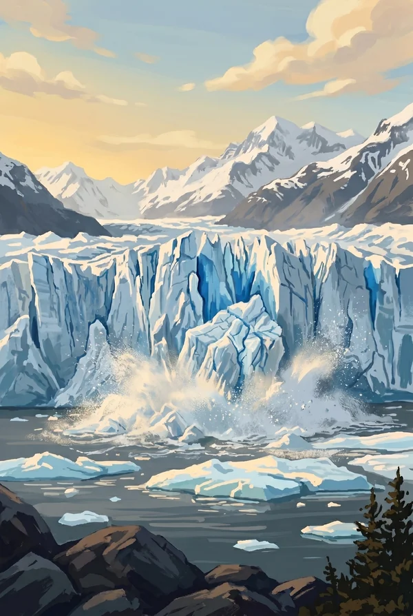
Margerie Glacier
The park's signature tidewater glacier, 21 miles long and about a mile wide at the face, standing roughly 250 feet above the water at the head of Tarr Inlet with another hundred feet below it. While most glaciers here retreat, Margerie has held its ground for decades. This is the face ships wait in front of, engines off, listening for the crack of calving ice.
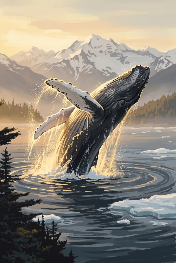
Humpback Whale
The summer resident that makes the 3,000-mile commute from Hawaii worth illustrating. Humpbacks feed in these plankton-rich waters all season, lunging through schools of fish and throwing their flukes on the dive; the pattern on the underside identifies the individual, and park researchers have tracked some of the same whales here for decades. The obvious pick for anyone who saw one breach.
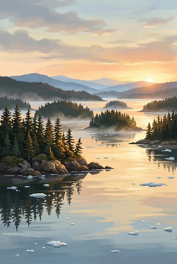
Beardslee Islands
A maze of low, forested islands off Bartlett Cove, the park's classic kayak water, and the newest land in it. Freed from the weight of the ice, the ground here rises about an inch a year, among the fastest uplift measured anywhere, so reefs shoal, channels close, and new islets keep surfacing. A stamp of a place that is literally still coming up.
How to record your Glacier Bay visit
Free, and it works whether you are standing there now or remembering a trip from years ago.
1
Check In at the park
Open ParkStamp inside the park boundary and check in. The app confirms you are actually there and logs the date.
2
Or Stamp It later
Already been? Pick the date yourself. Trips from decades ago count the same as last weekend.
3
Or scan your photos
Let ParkStamp read the dates and locations off photos already on your phone. Most people find parks they had forgotten.
Glacier Bay, asked and answered
Quick answers, for people planning a trip and people remembering one.
When is the best time to visit Glacier Bay?
Late May through early September, which is when the bay is realistically reachable and the whales are in residence; humpback numbers peak from June into August. Early summer tends to be the drier window in a place that is honestly never dry; September brings storms and emptier water. Whatever the month, pack for rain: the lower bay is temperate rainforest, and the weather changes by the hour.
How many days do you need at Glacier Bay?
Most visitors get one long day from the deck of a ship, and the bay delivers even at that. To touch the place, base at Bartlett Cove or Gustavus for two or three days: one on the water headed up-bay toward the tidewater glaciers, one paddling the Beardslee Islands, and one in the rainforest and at the Huna Tlingit tribal house.
How busy is Glacier Bay?
Glacier Bay National Park & Preserve logged 740,044 visits in 2025, the 32nd busiest of the 63 national parks. That puts it in the middle of the pack: busy at the famous spots, quiet a mile past them.
What does the Glacier Bay stamp show?
The lead Glacier Bay design is Margerie Glacier. The park's signature tidewater glacier, 21 miles long and about a mile wide at the face, standing roughly 250 feet above the water at the head of Tarr Inlet with another hundred feet below it. While most glaciers here retreat, Margerie has held its ground for decades. This is the face ships wait in front of, engines off, listening for the crack of calving ice. The other two designs are Humpback Whale and Beardslee Islands.
Is the Glacier Bay stamp free?
Recording your Glacier Bay visit is always free: check in at the park, add an old trip, or let the photo scan find it. The full-color art is the paid part, $3.99 one-time with three Glacier Bay designs to choose from, and the first stamp you collect in ParkStamp is free.
Can I add a Glacier Bay trip from years ago?
Yes. Open Glacier Bay in ParkStamp, tap Stamp It, and set the date yourself; a visit from decades ago counts the same as last weekend. If you still have photos from the trip, the photo scan can find and date it from their location tags, without your photos ever leaving your phone.
Do I have to be at Glacier Bay to get the stamp?
No. Check In is for when you are standing inside Glacier Bay, and it confirms you are actually there. Stamp It records any past visit on your honor, with your dates. Both are free and put the same stamp in your StampBook.
Start your StampBook with Glacier Bay
Free on iOS and Android. Your first stamp is on us.