The New River Gorge National Park & Preserve Stamp
The New River is, despite the name, one of the oldest rivers in North America, old enough that it cuts straight through the Appalachian Plateau instead of flowing around it. The newest thing here is the park itself, the 63rd and most recent addition to the list.
New River Gorge is one of the 63 national parks in ParkStamp, and each park comes with original stamp art drawn in the WPA poster tradition. Every design is a picture of a real, specific place: somewhere you can stand and compare against the stamp.
Recording a visit costs nothing. Check in from the rim, log a rafting trip from a decade ago, or let the app pull the dates and places out of photos already sitting on your phone.
The real NPS boundary, with the roads and towns you would actually use to get there.
New River Gorge, for people who count parks
An ancient river, a coal-black century, and a bridge that ended a 40-minute drive.
Geologists argue about exactly how old the New River is, but not about the conclusion: it is older than the mountains around it. Rather than draining off the Appalachian Plateau, it slices straight across it, which a river can only do if it was already there while the land rose underneath. The result is a gorge roughly a thousand feet deep, rimmed with a band of Nuttall sandstone so hard and clean that climbers have put up more than a thousand routes on it.
For a century this was an industrial corridor, not a scenic one. The Chesapeake & Ohio Railway pushed through the gorge in 1873 and dozens of company towns sprang up along the tracks to mine the New River coalfield's famous smokeless coal. Thurmond, reachable for decades only by rail, generated more freight revenue for the C&O than much larger cities; its population today is in the single digits and its depot is a park visitor center. At Nuttallburg, Henry Ford bought the mine in 1920 to feed his River Rouge plant directly, built a conveyor system down the gorge wall, and gave up within a decade: he could own the coal but not the railroad that carried it. The forest has been quietly taking all of it back ever since.
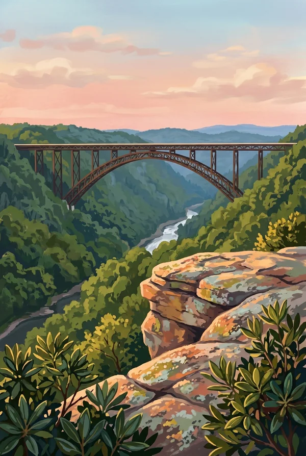
The bridge changed everything in 1977. Before it opened, crossing the gorge meant about 40 minutes of switchbacks on Fayette Station Road. After, less than a minute. At 3,030 feet long and 876 feet above the water (the Washington Monument would fit underneath with hundreds of feet to spare), it held the record as the world's longest single-span steel arch for 26 years, until Shanghai built a longer one in 2003. West Virginia put it on its state quarter. One day each October the bridge closes to traffic and opens to pedestrians and BASE jumpers, which is the only legal day of the year to jump off it.
The park designation rode in on an omnibus. The gorge had been New River Gorge National River since 1978. The upgrade to national park and preserve was tucked into the giant year-end spending and pandemic-relief bill signed December 27, 2020, making this the 63rd national park. The split matters locally: 7,021 acres became the park proper, while 65,165 acres became preserve where hunting continues, the compromise that got West Virginia's hunters to accept the new name.
A fish the color of candy, and bats that moved into the mines.
The candy darter looks like it was painted by someone showing off. A three-inch fish banded in teal, orange and crimson, native to a handful of streams in the New and Gauley drainages and nowhere else. It is federally endangered, and the main threat is genetic: the closely related variegate darter, introduced by anglers dumping bait buckets, hybridizes with it wherever the two meet. An ancient, long-isolated river breeds fish found nowhere else, and it has no defenses when the isolation ends.
The abandoned mines found a second career as bat caves. Old portals in the gorge walls hold the steady temperatures bats need, and endangered Virginia big-eared and Indiana bats use them. The Park Service gates the entrances with steel bars spaced to let bats through and keep people out, which is why you should never push past a barred opening in the woods here.
Peregrine falcons patrol the Endless Wall, and parts of the cliff close to climbers in spring while they nest, the same courtesy Zion extends its falcons. Below the rim, the gorge works as a north-south corridor of unbroken Appalachian forest, thick with rhododendron, black bears and more salamander species than most visitors would guess exist. The river itself, warm and rocky, is one of the best smallmouth bass fisheries in the country.
The New River Gorge designs
Pick the one that matches the park you actually saw.
New River Gorge Bridge
The third-longest single-span steel arch on Earth and the longest anywhere for 26 years after it opened in 1977: 3,030 feet across, 876 feet above the river. The classic view is from the boardwalk below the Canyon Rim Visitor Center. It is on the state quarter, and for one day each October, people jump off it on purpose.
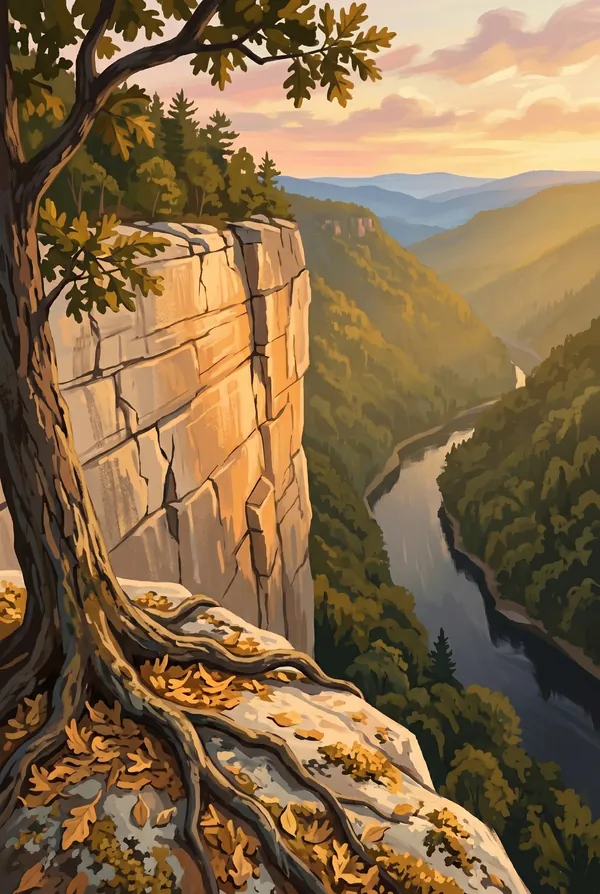
Endless Wall
A rim of Nuttall sandstone running unbroken for miles along the gorge's north edge, up to a hundred feet of vertical rock atop a thousand feet of forested slope. The walk between Fern Creek and Nuttall trailheads passes hemlock groves and ladder-accessed climbing routes, and Diamond Point gives the single best free view in the park.
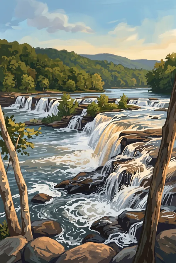
Sandstone Falls
The largest waterfall on the New River, about 1,500 feet wide and 10 to 25 feet tall, split by islands and braided into channels. It marks the line where the New stops being a broad valley river and starts tearing into its gorge. A boardwalk crosses to the islands, at the quiet southern end of the park most visitors never reach.
How to record your New River Gorge visit
Free, and it works whether you are standing there now or remembering a trip from years ago.
1
Check In at the park
Open ParkStamp inside the park boundary and check in. The app confirms you are actually there and logs the date.
2
Or Stamp It later
Already been? Pick the date yourself. Trips from decades ago count the same as last weekend.
3
Or scan your photos
Let ParkStamp read the dates and locations off photos already on your phone. Most people find parks they had forgotten.
New River Gorge, asked and answered
Quick answers, for people planning a trip and people remembering one.
When is the best time to visit New River Gorge?
October is the famous month: peak color on the gorge walls and Bridge Day crowds to match. Spring runs the river high for whitewater and covers the slopes in redbud and dogwood before the canopy closes. Summer is green, humid and busy with rafters; winter is quiet, with bare trees opening up rim views of the bridge that leaves hide the rest of the year.
How many days do you need at New River Gorge?
One day covers the north end: the Canyon Rim boardwalk for the bridge view, Endless Wall to Diamond Point, and the drive down old Fayette Station Road to the water. A second day earns the rest: a raft trip through the Lower Gorge rapids, or the drive south to Thurmond's ghost-town depot and the boardwalk islands at Sandstone Falls.
How busy is New River Gorge?
New River Gorge National Park & Preserve logged 1.96 million visits in 2025, the 17th busiest of the 63 national parks. That puts it in the middle of the pack: busy at the famous spots, quiet a mile past them.
What does the New River Gorge stamp show?
The lead New River Gorge design is New River Gorge Bridge. The third-longest single-span steel arch on Earth and the longest anywhere for 26 years after it opened in 1977: 3,030 feet across, 876 feet above the river. The classic view is from the boardwalk below the Canyon Rim Visitor Center. It is on the state quarter, and for one day each October, people jump off it on purpose. The other two designs are Endless Wall and Sandstone Falls.
Is the New River Gorge stamp free?
Recording your New River Gorge visit is always free: check in at the park, add an old trip, or let the photo scan find it. The full-color art is the paid part, $3.99 one-time with three New River Gorge designs to choose from, and the first stamp you collect in ParkStamp is free.
Can I add a New River Gorge trip from years ago?
Yes. Open New River Gorge in ParkStamp, tap Stamp It, and set the date yourself; a visit from decades ago counts the same as last weekend. If you still have photos from the trip, the photo scan can find and date it from their location tags, without your photos ever leaving your phone.
Do I have to be at New River Gorge to get the stamp?
No. Check In is for when you are standing inside New River Gorge, and it confirms you are actually there. Stamp It records any past visit on your honor, with your dates. Both are free and put the same stamp in your StampBook.
Start your StampBook with New River Gorge
Free on iOS and Android. Your first stamp is on us.