The federal government protected this land in 1832, forty years before Yellowstone and four years before Arkansas was a state. The water coming out of the ground today fell as rain around the time the pyramids were already old, and for nearly a century this was the smallest national park in America. Now it is the second smallest, and still the only one with a downtown.
Hot Springs is one of the 63 national parks in ParkStamp, and like all of them it gets original stamp art drawn in the WPA poster tradition. Every design is an illustration of a specific, real place in the park.
Recording your visit costs nothing. Check in from the park, log a trip you took years ago, or let the app read the dates and places off photos that are already on your phone.
The real NPS boundary, with the roads and towns you would actually use to get there.
Hot Springs, for people who count parks
Protected before the word "national park" existed, and built like a city because it is one.
Start with the date. On April 20, 1832, Congress set aside the hot springs of the Ouachita Mountains as a federal reservation, to keep the water itself in public hands. That is four decades before Yellowstone and four years before Arkansas statehood, which is why the park can claim to be the oldest protected land in the park system while ranking 18th on the list of national parks. The reservation was renamed Hot Springs National Park on March 4, 1921, and the oddity of the place is that Congress never intended a wilderness. It intended a spa.
The result is a park that is also a street. Bathhouse Row runs along Central Avenue in the middle of the city of Hot Springs: eight bathhouses built between 1892 and 1923, in an era when doctors prescribed thermal bathing for everything from rheumatism to syphilis and the federal government regulated the tubs, the attendants and the water itself. People called it the American Spa. Ballplayers came every spring to "boil out" the winter (Babe Ruth trained here), and in the gambling years the clientele ran to figures like Al Capone.
Then medicine moved on. Antibiotics did what the water could not, the bathhouses emptied out through the mid-20th century, and the Row spent decades as a preserved question mark. The Fordyce, the most ornate of the eight, became the park visitor center, stained glass and needle showers intact. The Buckstaff never closed at all; it has been bathing customers in the federal water continuously since 1912. The park still collects the spring flow and pipes it, untreated, to the bathhouses and the public fountains, where locals line up with jugs.
For 97 years this was the smallest national park, about 5,500 acres of mountain wrapped around a downtown, until Gateway Arch took the title in 2018. The size is the point. Nearly everything the park protects comes out of one hillside on Hot Springs Mountain, and everything else, from the forested Ouachita ridges to the overlooks and trails, exists to keep the plumbing intact.
A 4,400-year plumbing system, and a forest that exists to protect it.
The water is the wildlife here, so start with it. There is no volcano under Arkansas. Rain falls on the recharge zone, works its way down through fractured rock to a depth of around 8,000 feet, picks up heat from the normal temperature gradient of the Earth's crust, and rises fast along faults before it can cool. Isotope dating puts the round trip at roughly 4,400 years. It emerges from about 47 springs at an average of 143°F, hundreds of thousands of gallons a day, and because of the long filtration it comes up clean enough that the park serves it at drinking fountains.
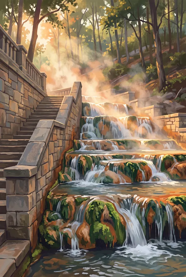
Where the hot water runs in the open, life follows it. Most springs are capped to protect the flow, but at the open displays the runoff channels grow mats of blue-green algae and build tufa, the pale porous rock left behind as dissolved minerals come out of solution. The steaming cascade on a cold morning is the park doing in public what it mostly does under lids.
Above the springs, an Ouachita mountain forest. The Ouachitas are an old, heavily eroded east-west range (unusual in North America, where most ranges run north-south), and the park's ridges carry oak, hickory and shortleaf pine, with dogwood and redbud underneath. White-tailed deer are common on the mountain roads at dusk, and the woods hold wild turkey, foxes and a long list of songbirds a few minutes' walk from Central Avenue. The forest is not incidental: it is the top of the recharge system, which is why the hillsides were protected along with the water.
The Hot Springs designs
Pick the one that matches the park you actually saw.
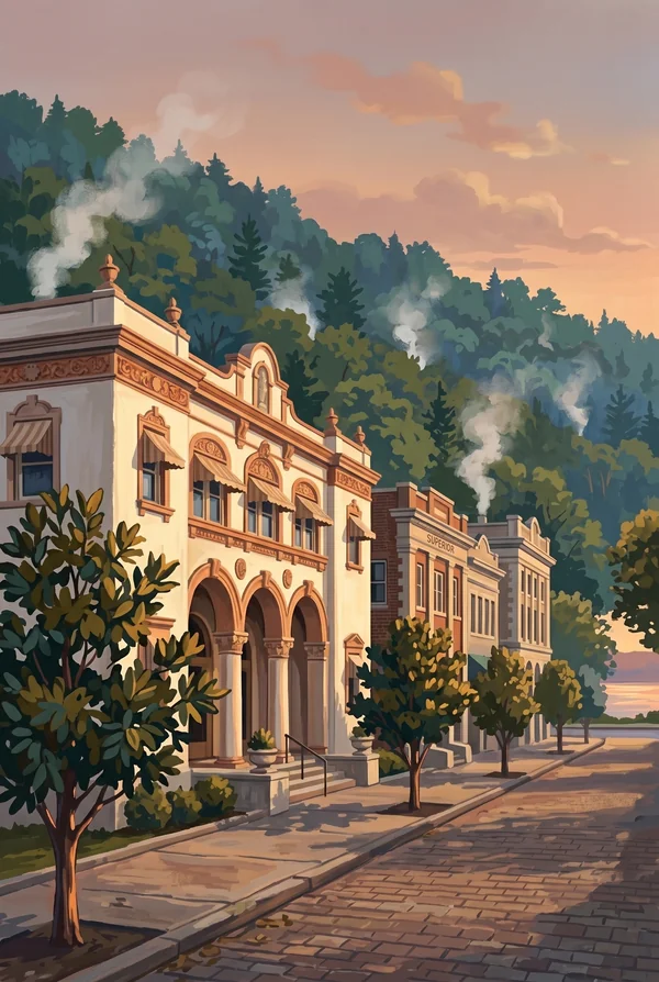
Bathhouse Row
Eight bathhouses shoulder to shoulder on Central Avenue, built between 1892 and 1923 and now a National Historic Landmark District. The Fordyce is the showpiece, with its stained-glass ceiling; the Buckstaff has bathed customers continuously since 1912. This is the only place in the park system where the signature landscape is a streetscape, which is exactly why people pick it.
Hot Springs Cascade
The open cascade where thermal water spills down the hillside over tufa rock it deposited itself, streaked with the blue-green algae that live in the hot flow. Most of the springs are sealed to protect the water, so this is the rare spot where you watch the park's whole reason for existing come out of the ground, steaming on cold mornings.
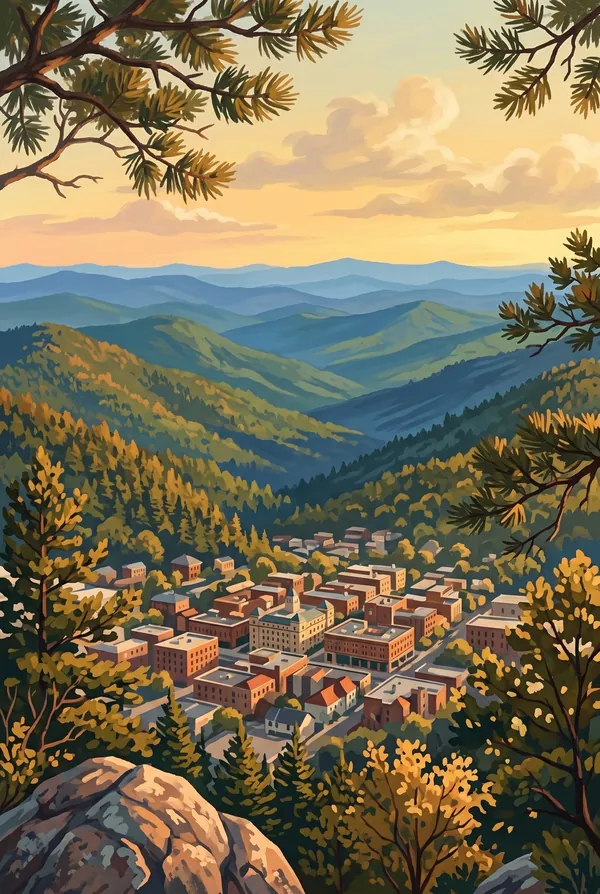
Hot Springs Mountain Tower View
From the observation tower on the summit of Hot Springs Mountain, successor to lookout towers that have stood here since the 1870s, the view runs across the folded, forested ridgelines of the Ouachitas with the city grid directly below. It is the one vantage that shows the park's strange arrangement plainly: a mountain forest and a downtown sharing the same boundary.
How to record your Hot Springs visit
Free, and it works whether you are standing there now or remembering a trip from years ago.
1
Check In at the park
Open ParkStamp inside the park boundary and check in. The app confirms you are actually there and logs the date.
2
Or Stamp It later
Already been? Pick the date yourself. Trips from decades ago count the same as last weekend.
3
Or scan your photos
Let ParkStamp read the dates and locations off photos already on your phone. Most people find parks they had forgotten.
Hot Springs, asked and answered
Quick answers, for people planning a trip and people remembering one.
When is the best time to visit Hot Springs?
Spring and fall. March and April bring dogwood and redbud bloom to the Ouachita hillsides, and late October through November turns the oak and hickory forest over the springs. Summer is hot and humid, though the bathhouses were air-conditioned by marble and thermal engineering long before the term existed. Winter is a sleeper pick: the baths are indoors, and the Hot Water Cascade steams best on cold mornings.
How many days do you need at Hot Springs?
One full day covers the essentials: Bathhouse Row and the Fordyce, the Grand Promenade, a drink from the fountains, and a walk up Hot Springs Mountain to the tower. Add a second day for an actual soak at one of the operating bathhouses and the quieter trails on West Mountain and the Sunset Trail loop.
How busy is Hot Springs?
Hot Springs National Park logged 2.49 million visits in 2025, the 14th busiest of the 63 national parks. That puts it in the middle of the pack: busy at the famous spots, quiet a mile past them.
What does the Hot Springs stamp show?
The lead Hot Springs design is Bathhouse Row. Eight bathhouses shoulder to shoulder on Central Avenue, built between 1892 and 1923 and now a National Historic Landmark District. The Fordyce is the showpiece, with its stained-glass ceiling; the Buckstaff has bathed customers continuously since 1912. This is the only place in the park system where the signature landscape is a streetscape, which is exactly why people pick it. The other two designs are Hot Springs Cascade and Hot Springs Mountain Tower View.
Is the Hot Springs stamp free?
Recording your Hot Springs visit is always free: check in at the park, add an old trip, or let the photo scan find it. The full-color art is the paid part, $3.99 one-time with three Hot Springs designs to choose from, and the first stamp you collect in ParkStamp is free.
Can I add a Hot Springs trip from years ago?
Yes. Open Hot Springs in ParkStamp, tap Stamp It, and set the date yourself; a visit from decades ago counts the same as last weekend. If you still have photos from the trip, the photo scan can find and date it from their location tags, without your photos ever leaving your phone.
Do I have to be at Hot Springs to get the stamp?
No. Check In is for when you are standing inside Hot Springs, and it confirms you are actually there. Stamp It records any past visit on your honor, with your dates. Both are free and put the same stamp in your StampBook.
Start your StampBook with Hot Springs
Free on iOS and Android. Your first stamp is on us.