Voyageurs is a national park you cannot drive into. The interior is a roadless peninsula wrapped by four big border lakes, and nearly everything in the park is reached by boat. It is named for the French-Canadian canoemen whose paddle route west was so well established that the treaty makers used it to draw the border between the United States and Canada.
Voyageurs is one of the 63 national parks in ParkStamp, and every park in the app gets original stamp designs drawn in the WPA poster tradition. Each design is an illustration of a real, specific place in the park, not a generic scene.
Recording a visit costs nothing. Check in while you are there, log a trip from any year past, or let the app pull the dates and locations from photos already sitting on your phone.
The real NPS boundary, with the roads and towns you would actually use to get there.
Voyageurs, for people who count parks
A border drawn by canoe, a gold rush that fizzled, and rock older than almost anything in America.
The border here follows a canoe route. For a century and a half the voyageurs, contract paddlers of the fur trade, moved furs and trade goods along this chain of lakes between Montreal and the Northwest. When the United States and British North America needed a boundary, the treaties reached for the line everyone already knew: the customary water highway of the voyageurs. That is why the border wanders through the middle of Rainy, Namakan and Sand Point lakes today, and why a park about canoemen sits exactly on it.
The park itself took decades of fighting. In the 1920s the industrialist E. W. Backus proposed a chain of dams that would have raised and flattened the border lakes into storage reservoirs. Ernest Oberholtzer, who lived on an island in Rainy Lake, led the opposition and spent much of his life at it. The campaign he helped start eventually produced the Boundary Waters wilderness next door and, further down the line, this park: authorized January 8, 1971, and formally established April 8, 1975, Minnesota's only national park. More than a third of its surface is water.
There was a gold rush here, briefly. Gold turned up on Little American Island in Rainy Lake in 1893, and a boomtown called Rainy Lake City appeared on the shore complete with saloons and a stamp mill. The ore never amounted to much, Little American was the only mine that paid at all, and within a decade the town had emptied out. The park still holds the workings, reachable like everything else by water.
The rock under all of it is absurdly old. This is the exposed edge of the Canadian Shield, more than two and a half billion years in age, some of the oldest rock at the surface anywhere in the United States. The glaciers scraped it bare and left ten thousand lakes of meltwater sitting in the scoured hollows; the park's lakes are simply the biggest local examples. What looks like wilderness scenery is a planed-off mountain root.
Wolves that fish and eat blueberries, and more beavers per square mile than almost anywhere.
The wolves here changed what science knew about wolves. Since the mid-2010s the Voyageurs Wolf Project has GPS-collared the packs of the Kabetogama Peninsula and caught them doing things wolves were not supposed to do: sitting in ambush beside beaver trails for hours, wading creeks at night to catch spawning fish, and in late summer eating blueberries in quantity. None of this was well documented anywhere before the cameras and collars went out in these woods.
The beavers are the reason. The peninsula holds one of the highest beaver densities in the lower 48, and their dams, ponds and abandoned meadows have reworked a large share of the interior. Beavers are both the park's chief landscape engineers and the staple prey of its wolves, which is why the two species' lives are so tangled here.
Loons and eagles run the waterline. Common loons nest along the island shores and their calls carry for miles over calm water; bald eagles nest here in numbers that would have seemed impossible in the DDT years. Both are fish-eaters, which is the whole logic of a park that is one part woods to one part water.
After dark the sky is part of the park. Voyageurs was certified an International Dark Sky Park in 2020, and it sits far enough north that the aurora borealis is a regular event rather than a rumor. On a still night the lakes double it.
The Voyageurs designs
Pick the one that matches the park you actually saw.
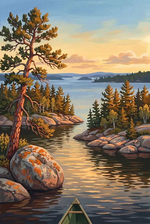
Kabetogama Lake Island Chain
Kabetogama is the lake without a Canadian shore, and its open water is broken by a scatter of forested bedrock islands, smoothed humps of Canadian Shield with pines growing out of the cracks. The campsites out here are reachable only by water, which filters the crowd down to people in boats. Pick it if the park, to you, means islands.
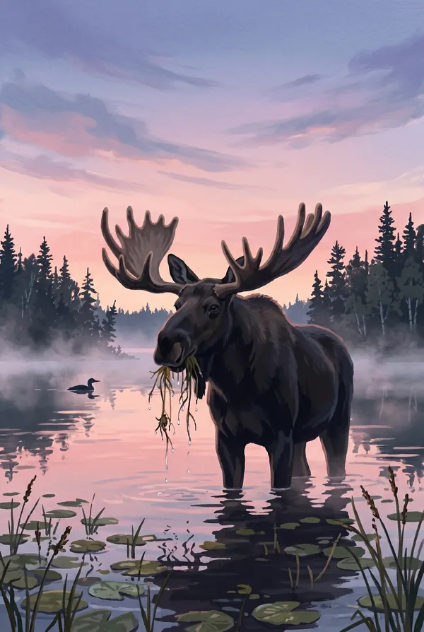
Moose at Dawn
Voyageurs sits near the southern edge of moose range, and its small population lives quietly in the roadless interior, feeding in shallow bays and swimming between islands. Seeing one is never guaranteed, which is the point: a dawn moose, hock-deep with water dripping from its muzzle, is the north-woods sighting people wait years for.
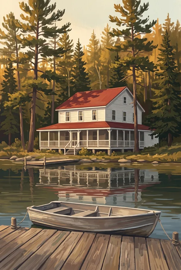
Kettle Falls Hotel
A white clapboard hotel from 1913, still the only lodging in the park and still unreachable by road. Its barroom floor settled on clay long ago and slopes so famously that restorers kept the tilt and leveled only the pool table. Stand at the dam outside and you are looking south into Canada, one of the border's stranger corners.
How to record your Voyageurs visit
Free, and it works whether you are standing there now or remembering a trip from years ago.
1
Check In at the park
Open ParkStamp inside the park boundary and check in. The app confirms you are actually there and logs the date.
2
Or Stamp It later
Already been? Pick the date yourself. Trips from decades ago count the same as last weekend.
3
Or scan your photos
Let ParkStamp read the dates and locations off photos already on your phone. Most people find parks they had forgotten.
Voyageurs, asked and answered
Quick answers, for people planning a trip and people remembering one.
When is the best time to visit Voyageurs?
Mid-June through September is the water season, when the lakes are open and warm enough to make island camping pleasant; early summer brings the biting flies, so August and September are the comfortable months, September adding fall color and empty campsites. Winter is a different park entirely: the lakes freeze into white plains, travel switches to skis, snowshoes and snowmobiles, and the long dark nights are prime aurora season this far north.
How many days do you need at Voyageurs?
Two to three days, and they must be spent on the water. The interior has no roads, so plan around a boat: your own, a rented houseboat, or a water taxi to an island campsite. A day trip can reach the Kabetogama islands or Ellsworth Rock Gardens, but Kettle Falls, where you look south into Canada, wants a full day of travel by itself.
How busy is Voyageurs?
Voyageurs National Park logged 206,326 visits in 2025, the 53rd busiest of the 63 national parks. That makes it one of the quieter national parks, and crowds are rarely the problem.
What does the Voyageurs stamp show?
The lead Voyageurs design is Kabetogama Lake Island Chain. Kabetogama is the lake without a Canadian shore, and its open water is broken by a scatter of forested bedrock islands, smoothed humps of Canadian Shield with pines growing out of the cracks. The campsites out here are reachable only by water, which filters the crowd down to people in boats. Pick it if the park, to you, means islands. The other two designs are Moose at Dawn and Kettle Falls Hotel.
Is the Voyageurs stamp free?
Recording your Voyageurs visit is always free: check in at the park, add an old trip, or let the photo scan find it. The full-color art is the paid part, $3.99 one-time with three Voyageurs designs to choose from, and the first stamp you collect in ParkStamp is free.
Can I add a Voyageurs trip from years ago?
Yes. Open Voyageurs in ParkStamp, tap Stamp It, and set the date yourself; a visit from decades ago counts the same as last weekend. If you still have photos from the trip, the photo scan can find and date it from their location tags, without your photos ever leaving your phone.
Do I have to be at Voyageurs to get the stamp?
No. Check In is for when you are standing inside Voyageurs, and it confirms you are actually there. Stamp It records any past visit on your honor, with your dates. Both are free and put the same stamp in your StampBook.
Start your StampBook with Voyageurs
Free on iOS and Android. Your first stamp is on us.